Bridges of Mauritius
Browse bridge photos from Mauritius, including river crossings, old stone bridges, road bridges, railway remains, coastal bridges, village crossings and historic structures captured by Explora photographers.
Read more about bridges in Mauritius
About Bridges in Mauritius
Bridges in Mauritius are easy to overlook. Most people cross them without thinking, usually on the way to a beach, a village, a waterfall or work. But look properly and they tell a quiet story about the island: rivers, ravines, old railway lines, sugar estates, colonial roads, mountain routes and coastal villages that needed to be connected somehow.
Some bridges are modern and practical. Others are old, narrow, weathered, partly hidden by vegetation or remembered mainly by locals. A few have become photo subjects in their own right, especially where the bridge sits above a river, near a cliff, beside an old road, or in a landscape shaped by rivers of Mauritius and valleys.
Why Bridges Matter in Mauritius
Mauritius is a small island, but it is crossed by many rivers, ravines and old estate roads. Bridges made movement possible between villages, sugar estates, ports, towns and agricultural areas. Without them, many short journeys would have been far more complicated. A river that looks harmless in dry weather can become a real obstacle after heavy rain.
Bridges also show how Mauritius developed over time. Stone bridges, railway bridges, road bridges and footbridges all belong to different periods of the island’s history. Some were built for carts and estate traffic. Some for trains. Some for modern vehicles. Others simply help people cross from one side of daily life to the other.
Types of Bridges in Mauritius
Bridge photos in Mauritius can include several types of structures: old stone bridges, modern road bridges, river crossings, railway bridge remains, footbridges, coastal bridges and small estate bridges hidden in rural landscapes.
Each type tells a different story. A modern road bridge shows movement and infrastructure. An old stone bridge suggests history and craftsmanship. A railway bridge remnant points to the former transport network. A small village crossing shows daily life. Together, they form part of the island’s built landscape.
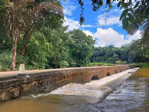
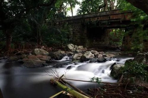
Historic Stone Bridges
Several old bridges in Mauritius still carry a sense of history. They may not always be famous tourist attractions, but they are part of the island’s built heritage. You can find stonework, arches, narrow crossings, old masonry and small bridges near former estate lands or older village roads.
These structures are especially interesting for photographers who like historic buildings and old religious sites in Mauritius, architecture, texture and old details. Weathered stone, moss, rust, river water, shadows and surrounding greenery can make a bridge feel more atmospheric than expected. Not flashy. Just quietly beautiful.
Road Bridges
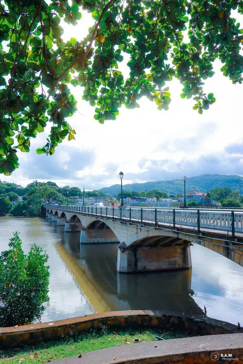
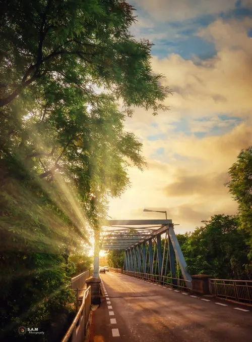
Many bridges in Mauritius are everyday road bridges over rivers, drains, ravines or small watercourses. You find them on village roads, mountain roads, coastal roads and main routes across the island.
These ordinary bridges can still make good photos when the setting is right. A road bridge in a village, a bridge over a river after rain, a crossing surrounded by trees, or a narrow bridge beside sugarcane fields in Mauritius can show a very real side of the island.
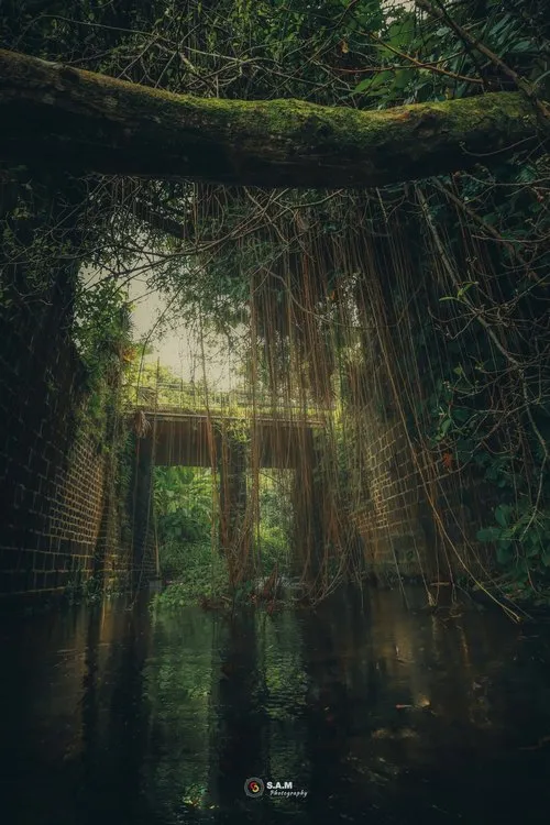
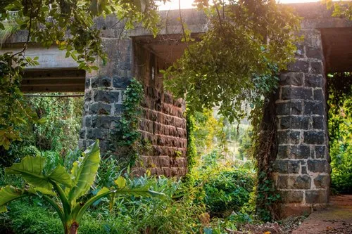
Old Railway Bridges and Railway Remains
Mauritius once had a railway network, and some bridge remains still recall that period. Old railway bridges and narrow-gauge railway structures can be found or remembered in places such as Réduit, Moka, Quartier Militaire, Rose Belle, Médine, La Laura and other former railway or estate-linked areas.
Not all of these structures are easy to visit, and some may be ruins or located on private or difficult-to-access land. Still, they form part of the island’s transport heritage and can be interesting subjects for historical photography.
Footbridges and Village Crossings
Footbridges and small village crossings are often more modest than road bridges, but they can be very photogenic. They may cross streams, drains, rivers or narrow ravines, helping people move between houses, fields, shops, schools and paths.
These bridges are interesting because they are close to everyday life. A simple footbridge with people crossing, children walking home, trees in the background or water flowing below can tell a stronger story than a large concrete bridge with no context.
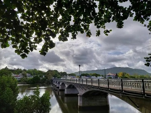
Coastal Bridges and River Mouth Crossings
Some bridges in Mauritius sit near the coast, river mouths or estuaries. These places can be visually rich because they combine sea, river, roads, boats, mangrove-like vegetation, rocks and village activity.
Coastal bridges are useful for photos that connect the inland and seaside landscapes of Mauritius. A river flowing under a bridge towards the lagoon can show how water, roads and coastal life meet in one place.
Notable Bridges and Bridge Sites in Mauritius
Some bridges and bridge-related sites in Mauritius are especially interesting because of their history, location, structure or photographic value. The list below is visitor-oriented and useful for photo research, but it should not be treated as a complete engineering inventory of every bridge on the island.
Rivière des Anguilles Bridge
The Rivière des Anguilles Bridge is one of the better-known old bridges in the south of Mauritius. It is linked to the village of Rivière des Anguilles and crosses a river that has long been part of the area’s identity.
The bridge is often appreciated for its height, stone structure and surrounding landscape. It is the kind of place where the road, river and old construction work together visually. A simple crossing, yes, but with character.
Cavendish Bridge in Mahebourg
Cavendish Bridge is one of the bridge names associated with the south-east of Mauritius and the Mahebourg region. Because Mahebourg is a place rich in history, waterfront views and old streets, bridge structures in this area naturally connect with the wider heritage of Grand Port.
For photographers, Mahebourg village and waterfront scenes can be combined with bridge details, river crossings, bay views, boats and old roads. The bridge becomes part of a broader south-east story rather than a single isolated structure.
Grand River North West Bridge
The Grand River North West area has an important bridge history, especially because of its position near the routes leading towards Port Louis city and harbour. The river and its crossings have been part of the island’s transport story for a long time.
Old images and bridge records linked to the Grand River North West area show how crossings evolved from earlier bridge structures to later railway and road connections. For anyone interested in the older infrastructure of Mauritius, this area is worth noting.
Le Réduit and Moka Railway Bridge Areas
The Réduit and Moka areas are linked with old railway routes, estate lands, rivers, bridges and central island movement. Railway remains and bridge sites in this region are interesting because they connect infrastructure with the older inland development of Mauritius.
These places are not always obvious tourist attractions, but they can be useful for photographers interested in history, old transport routes, rivers and hidden built heritage.
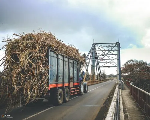
Estate and Sugar Region Bridges
Many bridge sites in Mauritius are connected with former sugar estates, estate roads and agricultural regions. Small bridges helped carts, workers, trains, tractors and later road vehicles move across streams, ravines and irrigation channels.
These bridges are part of the wider history of sugarcane landscapes in Mauritius. A small bridge near cane fields, an old chimney, a dirt road or a rural crossing can be visually simple, but it often has a strong sense of place.
List of Bridge Names and Bridge-Related Sites
Notable bridge names and bridge-related sites in Mauritius include Bagatelle Bridge, Beau Champs Bridge, Cavendish Bridge in Mahebourg, Ford Bridge, Fropier Bridge in Pamplemousses, Girder Bridge in Souillac, Grand Bois Foot Bridge, Grand River North West Bridge, Grande Rivière Noire Bridge, GRNO Railway Bridge, Gros Ruisseau Bridge at Rivière des Anguilles, Haute Rive Road Bridge, Hermitage Bridge, Ilot Bridge, Jamin Bridge at L’Escalier, John Kennedy Avenue Bridge in Vacoas, La Flora Bridge, La Laura Narrow Gauge Railway Bridge, La Lucie Bridge, Le Plessis Bridge, Le Pouce Bridge, Le Réduit Bridge, Le Réduit Metro Express Railway Bridge, Le Val Road Bridge, Le Val Sugar Estate Bridge, L’Escalier Bridge, Maillard Bridge at Calebasses, Mare Chicose Bridge, Mare Tabac Bridge, Martial Noel Bridge, Martindale Bridge at Réduit, Médine Bridge, Midlands Bridge, Moka Line Railway Bridge, Mon Goût Road Bridge, Napoleon Bridge at L’Avenir, Pointe aux Caves area crossings, Rivière des Anguilles Bridge and several old estate, railway and road bridges across the island.
This list brings together bridge names that may appear in old records, local references, maps, road networks or photo collections. Some are active road bridges, some are historical references, and others may be difficult to access today.
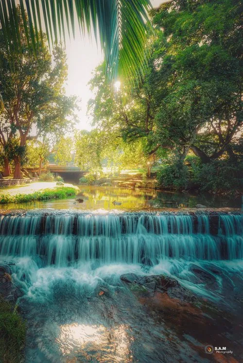
Bridges, Rivers and Waterfalls
Many bridges in Mauritius are closely linked to rivers, and rivers often lead the eye towards other natural scenes such as waterfalls of Mauritius, valleys and forest areas. A bridge over a dry riverbed may look ordinary in summer, then become a completely different scene after heavy rain.
This is why bridge photography can change a lot with the season. After rainfall, water movement, reflections and vegetation can make a simple bridge much more interesting. During dry periods, the structure itself, the road and the surrounding landscape become more important.
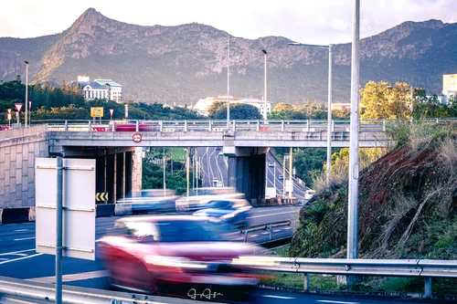
Bridges, Roads and Vehicles
Bridges are naturally linked with roads of Mauritius and vehicles in Mauritius. Cars, buses, motorcycles, trucks, tractors and pedestrians all use bridges as part of everyday movement across the island.
For photography, a bridge with traffic can sometimes tell a better story than an empty bridge. A bus crossing a village bridge, a tractor moving near cane fields, a car passing over a river after rain or a pedestrian crossing a narrow footbridge can show how infrastructure supports daily life.
Bridges in Villages and Towns
In villages and towns of Mauritius, bridges are often part of everyday movement. People cross them on foot, by car, by bus, by bicycle or by motorbike, sometimes without noticing the river below.
For photographers, this gives bridges a human side. A bridge can frame local life: schoolchildren walking home, buses passing, fishermen nearby, roadside vendors, old houses, small temples, riverbanks or people stopping for a quick chat. Not every bridge photo has to be empty.
Bridge Photography in Mauritius
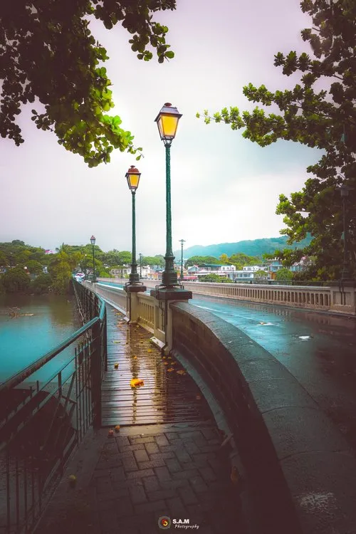
Bridge photos work best when you look for context. The bridge alone may be interesting, but the surroundings usually make the image stronger: water below, trees, road curves, old stonework, cliffs, people, vehicles, shadows or a view into the distance.
Early morning and late afternoon can help, especially when the light creates texture on stone, metal or concrete. Cloudy weather can also work well for old bridges because it softens harsh shadows and brings out details. A little rain? Even better sometimes. Just mind the slippery parts.
Best Bridge Photo Subjects
Good bridge photo subjects in Mauritius include stone arches, old railway remains, road bridges over rivers, footbridges in villages, bridges near sugarcane fields, coastal crossings, bridge reflections, people walking across, vehicles passing, and river water after rain.
For a stronger image, include a subject that gives scale. A person, bus, bicycle, car, fishing rod or even a small dog crossing the bridge can make the structure feel more alive.
Best Time to Photograph Bridges
Morning and late afternoon are usually the best times to photograph bridges, especially old stone or metal structures. The softer light brings out texture and reduces harsh shadows.
After rain, bridges over rivers can become more interesting because the water level, reflections and vegetation change. But safety becomes more important too, especially near slippery stones, muddy paths and fast-flowing water.
Safety and Access
Some bridges are on busy roads, narrow crossings, private land or unsafe old structures. Visitors and photographers should avoid standing in traffic, climbing on barriers, entering restricted areas or walking on unstable ruins.
A bridge may look like a nice photo spot, but safety comes first. Use proper stopping areas, respect signs and private property, and be especially careful near rivers after heavy rain. Water levels can rise quickly in Mauritius, and old stones can be more slippery than they look.
Bridge Photos from Mauritius
Explore photos of bridges in Mauritius, from old stone crossings and river bridges to road bridges, railway remains, village crossings, coastal routes and historic structures across the island.